Also, you can use Political Map script together with ShutterPlace script (which shows the country names). satinka, big thanks for ShutterPlace script! ---> https://gist.github.com/satinka/5479a93d389a07d41246
ver1.2 - works with all supported languages and https ver1.5 - the code is optimized, added: customizable dot, cute map - by css0101 ver1.7 - previews is gradually hiding when cursor is hovering above - by css0101 ver1.8 - dot with uncertain coordinates replaced by red square, also you can hide it by white #FFFFFF ver1.9 - fixed some errors
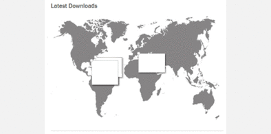


Detailed Political Map - normal size
Description:
Standard gray map is replaced by detailed political map
http://freestyler.ws/style/132953/detailed-big-political-mapcss0101, big thanks for cute map design and code!
Also, you can use Political Map script together with ShutterPlace script
(which shows the country names).
satinka, big thanks for ShutterPlace script! ---> https://gist.github.com/satinka/5479a93d389a07d41246
Donate: https://dl.dropboxusercontent.com/u/96409476/Thanks.txt
More info
ver1.5 - the code is optimized, added: customizable dot, cute map - by css0101
ver1.7 - previews is gradually hiding when cursor is hovering above - by css0101
ver1.8 - dot with uncertain coordinates replaced by red square,
also you can hide it by white #FFFFFF
ver1.9 - fixed some errors
old map design: https://dl.dropboxusercontent.com/u/96409476/map.png
http://freestyler.ws/style/132953/detailed-big-political-map
Planned: realtime timezone shading map:
https://dl.dropboxusercontent.com/u/96409476/map0.png
First install FreeStyler to use this style.
If you already installed it, please, make sure this site is allowed to run JavaScript.But you can download Freestyler for other browsers and apply styles there!
Applies to:
http://submit.shutterstock.com/home.mhtml, https://submit.shutterstock.com/home.mhtml